
Castle Surveys
Stand B13
Castle Surveys Ltd – Pioneers in Geomatic and Surveying Solutions
Castle Surveys Ltd stands at the forefront of geomatic and surveying solutions, delivering high-quality, innovative, and tailored services to clients across various sectors. With national and international reach, we take pride in offering a comprehensive suite of survey services, from traditional topographic and measured building surveys to cutting-edge mobile mapping and digital documentation. As a trusted partner to both public and private sectors, Castle Surveys Ltd provides crucial support in infrastructure, construction, highways, and asset management projects.
Our approach to surveying is grounded in excellence and innovation, with a dedicated focus on precise data collection and the latest advancements in surveying technology. We deploy state-of-the-art equipment and software to deliver data-rich outputs, such as 3D models, BIM-compliant deliverables, and highly accurate asset management data.
Services Offered by Castle Surveys Ltd
Topographic Land Surveys
Using the latest in Leica total stations and GNSS technology, we provide detailed and accurate topographic surveys tailored to our clients’ needs. Our surveys are critical in providing the foundation data for design, planning, and construction projects.
Measured Building Surveys
Our team captures precise building dimensions and layouts using high-definition Leica RTC360 laser scanners and NavVis systems, providing clients with highly detailed CAD and BIM models for design, renovation, and space planning.
PAS128 Underground Utility Surveys
With advanced GPR (Ground Penetrating Radar) and Vivax locators, we conduct non-intrusive underground utility surveys. Our services include mapping of all subsurface utilities, critical for reducing risk during excavation and construction projects.
CCTV Drainage Surveys
Our specialized CCTV drainage team, supported by advanced equipment, assesses and maps drainage systems, providing reports essential for maintenance and design of new systems.
Revit and ArchiCAD BIM Modelling
Castle Surveys creates comprehensive Building Information Models (BIM) in compliance with the latest industry standards, delivering models from LoD 200 up to LoD 400, supporting efficient project planning, design, and facility management.
Mobile Mapping and Digital Twin Creation
With mobile mapping capabilities, we provide fast, high-accuracy, 360-degree data collection, ideal for highways and large-scale infrastructure. Our mobile mapping solutions support digital twin creation for real-time asset management, aiding clients in managing large assets efficiently.
Drone Surveys & Inspection
Our certified drone operators use high-resolution drone cameras to capture hard-to-reach locations and create detailed aerial imagery and point clouds, essential for complex projects such as roof inspections and heritage site documentation.
Construction Progress Monitoring
We support project teams by providing regular, accurate updates on construction progress through 360° walkthroughs, digital documentation, and 3D model updates, essential for project management and stakeholder transparency.
Boundary and Legal Surveys
Our boundary surveys provide clear, legally-defensible documentation that ensures our clients have accurate and compliant information for land ownership, planning, and development purposes.
Specialized Highways & Infrastructure Solutions
Our team’s expertise in highways and infrastructure projects is enhanced by innovative mobile mapping technologies. We use advanced mobile data collection methods to deliver high-accuracy, high-density point clouds and 360° panoramic images, essential for highway asset management. Our mobile mapping services provide clients with up-to-date asset inventories and condition assessments, helping streamline maintenance, reduce operational costs, and optimize asset lifespan. This innovation supports data-driven decisions and boosts efficiency in infrastructure planning and maintenance.
Office Locations
To provide nationwide support, Castle Surveys Ltd operates from five strategically located offices:
London Office
Midlands Office
Manchester Office
Southwest Office
Scotland Office
With a nationwide presence and industry-leading expertise, Castle Surveys Ltd is dedicated to helping clients achieve accurate, efficient, and cost-effective results across their projects. Our commitment to quality, combined with a forward-thinking approach to surveying, ensures we remain a trusted partner in the industry, advancing infrastructure development and asset management through high-tech data collection and analysis.
Documents
Products
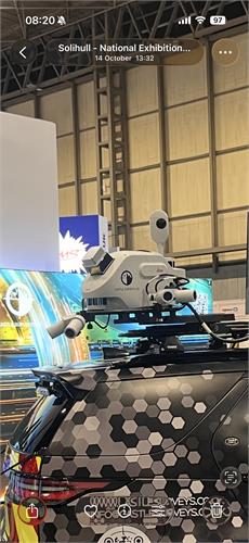
Mobile Mapper - Leica TRK Neo
Mobile mapping surveys are an advanced method of capturing high-accuracy geospatial data using sensors mounted to a vehicle. Instead of relying on static instruments and manual point-by-point measurements, mobile mapping enables surveyors to collect dense, 360-degree data while travelling at normal traffic speed.
At the heart of the process are high-resolution LiDAR scanners, GNSS receivers, and inertial measurement units (IMUs), often combined with panoramic cameras. Working together, these sensors record millions of points per second, building a precise digital model of the surrounding environment. The result is a detailed 3D point cloud that can be processed into CAD drawings, BIM models, and GIS datasets.
Unlike traditional topographic surveys, which require extended time on site and often involve lane closures or safety risks, mobile mapping technology drastically reduce fieldwork. This approach not only increases efficiency but also improves safety by minimising the need for surveyors to work on or near live roads and railways.
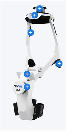
NavVis VLX3
NavVis VLX 3 is the industry-leading, wearable dynamic scanning system that efficiently delivers comprehensive, highly detailed reality capture data to laser scanning professionals and surveyors for large, complex sites, both indoor and outdoor.
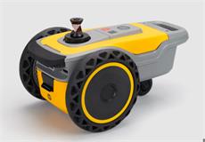
HP Site Print - Robotic Layout Solution
The HP SitePrint is redefining on-site construction layout by bringing robotic automation and digital precision directly to construction and surveying projects. At Castle Surveys Ltd, the integration of SitePrint into our surveying workflows represents a leap in technological capability – a solution purpose-built to deliver rapid, accurate, and highly efficient ground markings from digital plans to physical spaces.
What is HP SitePrint? The HP SitePrint is a compact, autonomous robot designed to bring digital plans to life right on the job site. It reads CAD and BIM files and prints precise lines, arcs, shapes, and even text directly onto surfaces like concrete, wood, tarmac, or vinyl. With accuracy within 3 millimetres, it gives construction teams clear, reliable markings that improve communication and coordination between architects, engineers, and installers.