
G2 Survey
Stand B1
Snapshot
G2 Survey stands for "Generation Two", reflecting our evolution from our inception as Opti-cal Survey Equipment Ltd, previously the UK’s leading distributor for survey equipment. We are the go-to geospatial equipment specialists. We specialise in next-generation survey measurement, positioning, and detection equipment.
What We Do
G2 Survey operates on four pillars:
1. Sales of new and refurbished surveying equipment
2. Hire of surveying equipment
3. Service and calibration
4. Support and training
We partner with Leica Geosystems as an Authorised Distributor and Service Partner and a BLK Premium Partner, bringing to you the forefront of innovative technology, including the most advanced 3D Laser Scanners, Robotic Total Stations, and GNSS Solutions. Alongside Leica Geosystems we supply a number of world class surveying brands including Radiodetection, Nedo, Rothbucher Systeme, Survipod and Vivax Metrotech.
Who We Serve
We cater to surveying professionals, contractors, civil engineers, utility providers, and entities within the construction and geospatial industries, ensuring high service levels synonymous with the esteemed brands we represent. Whether it’s scanning, measuring, mapping, modelling, positioning, detecting, or monitoring, G2 Survey is equipped with the expertise and solutions to help you realize your objectives.
Our Promise
Our focus is unwavering: meeting current and future customer needs, supporting innovative solutions, upholding high ethical and quality standards, maintaining a safe workplace, and fostering environmental stewardship.
Our Services
Beyond sales and hire, we offer national support, repair and calibration services, alongside comprehensive technical support and training.
Our Journey
We pioneered with Opti-cal Survey Equipment Ltd, setting high standards in customer service and innovative solutions, becoming the biggest survey equipment distributor in the UK before being acquired by a FTSE100 company in 2016. Adapting to the evolving landscape, G2 Survey was founded, emphasising e-commerce, cutting-edge support, and integrated back-office systems. To continue our legacy of service excellence, we’ve reunited with seasoned team members from our Opti-cal days.
Our Future
G2 Survey is committed to being a catalyst in the industry, emphasizing innovation and sustainability in delivering world-class products and services.
Why Choose G2 Survey?
If you seek unparalleled expertise and solutions in the realms of surveying and geosystems, G2 Survey is your ideal partner. We pride ourselves on our history, our commitment to quality and innovation, and our relentless pursuit of excellence in serving your needs.
Documents
-
G2 Survey Laser Scanning BrochureRedefining reality capture with next-generation technology
Products
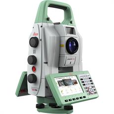
Leica Nova TM60 Robotic Total Station
The perfect total station for permanent and campaign monitoring projects.
The robust, precise and enduring Leica Nova TM60 helps with monitoring projects whenever you need to collect data securely and continuously. It comes with a firm promise: real-time information and reports you can always rely on, helping you make informed decisions in time and on time.
Be it settling, flexing, shifting, sliding or any other change of state – you will have it under control 24 hours a day, seven days a week. The TM60 Leica comes with the world’s longest ATRplus range, half-second automatic aiming accuracy, advanced imaging and the longest continuous operation.
Retail Price: £26,100.00
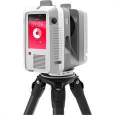
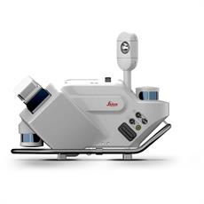
Leica RTC360 3D Laser Scanner
Hands down this is the fastest 3D laser scanner in its class, making 3D reality capture faster than ever before.
Automatically pre-register point cloud data in the field to quickly conduct quality control checks, improve productivity and make better-informed decisions on site with the Leica RTC360 Laser Scanner.
The Leica RTC360 3D Laser Scanner reality capture solution empowers users to document and capture their environments in 3D, improving efficiency and productivity in the field and in the office through fast, simple-to-use, accurate, and portable hardware and software. The RTC360 3D laser scanner is the solution for professionals to manage project complexities with accurate and reliable 3D representations and discover the possibilities of any site.
Retail Price: £39,995.00
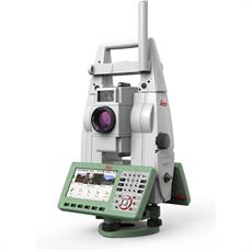
Leica TS16 Robotic Total Station
Meet the world’s first self-learning total station. Automatically adjusting to any environmental conditions, the Leica Viva TS16 locks onto your, and only your, target. Regardless of how challenging the task or the amount of distractions in the field, this total station exceeds your expectations.
Cover a wide range of applications when this total station sees precisely what you see. Known for the most comprehensive imaging capability available, you can capture exact conditions for any worksite through the self-learning capability of the Leica Viva TS16.
Trade Price: £23,995.00
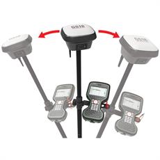
Leica GS18 T GNSS RTK Rover
Leica GS18 T – World’s Fastest GNSS RTK Rover
Immune to magnetic disturbances and calibration-free – no need to level
You no longer need to hold the pole vertical to level the bubble with the new Leica GS18 T, the fastest and easiest-to-use GNSS smart antenna and RTK rover. This latest innovation combines GNSS and inertial micro units (IMUs) to be the first true tilt compensation solution immune to magnetic disturbances and is calibration-free.
As you no longer need to watch and level the bubble, you can focus on your task at hand and save time over conventional surveying practices. Uninterrupted, accurate positioning when surrounded by or in close proximity to metallic objects - measure where others simply couldn’t before. The GS18 T works directly out of the box without any calibration procedure.
Trade Price: £17,950.00
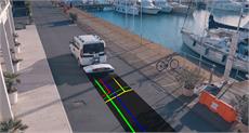
Leica Pegasus TRK Neo Mobile Mapping
The Leica Pegasus TRK solution uses artificial intelligence capabilities to transform mobile mapping. The advanced dynamic laser scanning and expandable imagery system for recording, measuring and visualizing environments increases productivity with automated, intelligent workflows. The Pegasus TRK is so light that it can be operated by one person, making mapping projects more efficient and cost-effective.
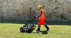
Stream UP Ground Penetrating Radar
Stream UP is an innovative multi-channel, multi-frequency, double-polarized and lightweight GPR system dedicated to utility mapping on extensive areas that facilitates the whole process (before, during and after data acquisition).
Stream UP is a GPR system able to operate in urban environment without slowing down the traffic (up to 150 km/h, with a suggested acquisition speed of 60 km/h). The system can be carried even on the same vehicle used for the acquisition thanks to its compactness that increases its transportability.
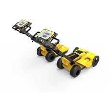
Stream DP Ground Penetrating Radar
Stream DP is the revolutionary multichannel GPR array solution for real-time 3D mapping of underground utilities and features that overturns the state-of-the-art in underground surveys. Featuring the new radical Equalized scrambled Technology - EsT by IDS GeoRadar, Stream DP brings underground assets detection to the next level: the deepest one.
This ground penetrating radar offers unmatched performance maximizing asset detection to a deeper range compared to any other solution available on the market.
Ergonomically designed for easy handling and transportation, Stream DP can be efficiently deployed by a single user thanks to its light weight (max. 20kg per part) and its compact size that fits in a standard vehicle (116cmX82cm).
Leica DS2000 Utility Detection Radar
There’s a lot going on underground that you need to know about before you ever start to dig. The Leica DS2000 Utility Detection Radar finds all potential threats, including non-conductive pipes and fibre optics, increasing safety by lowering the risk of accidentally hitting underground assets.
Increase safety, speed up work and lower asset management costs with the ability to prevent hazardous outages and collect more information. The DS2000 betters your business by making it safer, faster and more efficient.
Videos
RTC360 x G2SURVEY
Leica RTC360 3D Laser Scanner